Project area/S
- Data Intensive Astronomy
- Translation and Impact
Project Details
One of ICRAR-UWAs successful translation and impact projects has been working with The Ocean Institute to provide swell forecasts for organisations on the North West Shelf of WA using Machine Learning.
This project aims to apply this approach to buoy data collected from the South West coast of Western Australia and predict the wave heights at a Perth beach. Using buoys located at Cape Naturalliste, Mandurah, and Rottnest, the project will aim to predict the wave conditions at Cottesloe beach, where a buoy will provide the ground truth, as shown in Figure 1.
The buoys record 2D wave energy spectral data in direction and swell. This swell originates in the ocean to the SW of Cape Naturalliste (Figure 2), and the different frequency waves travel at different speeds towards Perth.
From the 2D spectra (Figure 3), we can then calculate the Wave Height, the swell’s direction and the swell’s period every hour. This will give a good indication of what the surf conditions will be like for the next 4-6 hours.
Student Attributes
Academic Background
Maths/Physics
Computing Skills
Python, Linux – Mandatory
Training Requirement
Pawsey HPC, Machine Learning
Project Timeline
- Week 1 Inductions and project introduction
- Week 2 Initial presentation
- Week 3 Data Investigation looking at real wave buoy data
- Week 4 Data Investigation looking at real wave buoy data
- Week 5 Develop/test approach
- Week 6 Develop/test approach
- Week 7 Test and evaluate
- Week 8 Prepare report
- Week 9 Final presentation
- Week 10 Final report
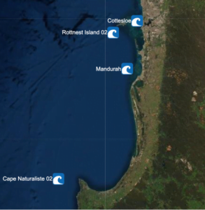
Figure 1: Buoy Locations off of South West Western Australia
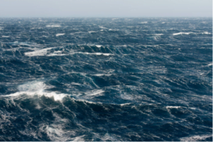
Figure 2: The swell in the open ocean
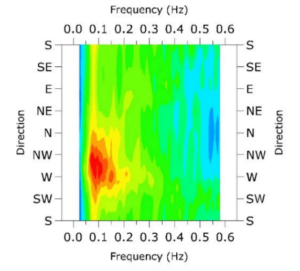
Figure 3: The 2D Spectra of wave energy plotted Frequency vs Direction
Additional Supervisors
- Dr. Jeff Hansen (School of Earth Sciences, UWA)